I was recently navigating a winding mountain road, relying solely on my phone's GPS, when the signal dropped for a moment. Suddenly, I felt completely lost. It struck me just how much we take this ubiquitous technology for granted. We pull out our phones, type in a destination, and within seconds, a voice guides us turn by turn, seemingly knowing our exact position down to a few feet. But have you ever stopped to wonder, **how does this magic actually work?** How do tiny satellites hundreds of miles above Earth communicate with a device in your pocket to pinpoint your precise location?
It’s a question that, when I first considered it, felt like a sci-fi concept brought to life. Yet, the Global Positioning System (GPS) is a marvel of engineering, physics, and advanced computing that operates silently in the background of our daily lives. It’s far more than just a map app; it’s a foundational technology that underpins everything from modern transportation and agriculture to emergency services and even global financial markets. Understanding its inner workings not only demystifies this everyday "magic" but also reveals the intricate dance between satellites, atomic clocks, and the subtle warping of spacetime predicted by Einstein himself.
### The Constellation in the Sky: GPS Satellites
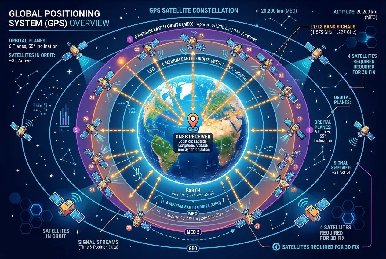
At the heart of the GPS system is a network of satellites orbiting Earth. Originally developed by the United States Department of Defense, GPS is now a global public utility. There are typically **31 active GPS satellites** at any given time, though the system only requires 24 to function optimally. These satellites are arranged in six orbital planes, ensuring that at least four satellites are visible from almost anywhere on Earth's surface at any given moment.
Each GPS satellite circles the Earth twice a day at an altitude of approximately 20,200 kilometers (12,550 miles). They are not stationary; they are constantly moving, broadcasting signals as they travel. These signals are the lifeblood of GPS, carrying crucial information that your receiver uses to calculate its position. Think of them as cosmic lighthouses, each flashing a unique beacon of data.
### The Language of Time: How Signals Work
The fundamental principle behind GPS is incredibly simple in concept, yet complex in execution: **time.** Each GPS satellite carries multiple atomic clocks, which are incredibly precise timekeeping devices. These clocks are so accurate that they would lose only about one second every 300,000 years. Every satellite broadcasts a signal that contains two main pieces of information:
1. **Its precise orbital position (ephemeris data):** This tells your GPS receiver exactly where the satellite is in space at any given moment.
2. **The exact time the signal was sent:** This is the critical piece for determining your distance.
When your GPS receiver (the device in your phone, car, or watch) picks up these signals, it notes the time the signal was *received*. Since it already knows the time the signal was *sent* (from the satellite's broadcast), it can calculate the travel time of the signal. Because radio waves travel at a known speed (the speed of light), the receiver can then determine its distance from each satellite. This calculation is a simple distance = speed × time formula.
However, there's a catch: your phone's clock isn't as accurate as an atomic clock. If your phone's clock were even slightly off, its distance calculations would be wildly inaccurate. To compensate for this, GPS receivers actually calculate a fourth unknown: **the receiver's clock error.** By measuring the distance to at least four satellites, the receiver can not only determine its precise 3D position (latitude, longitude, and altitude) but also synchronize its internal clock with the highly accurate atomic clocks of the satellites.
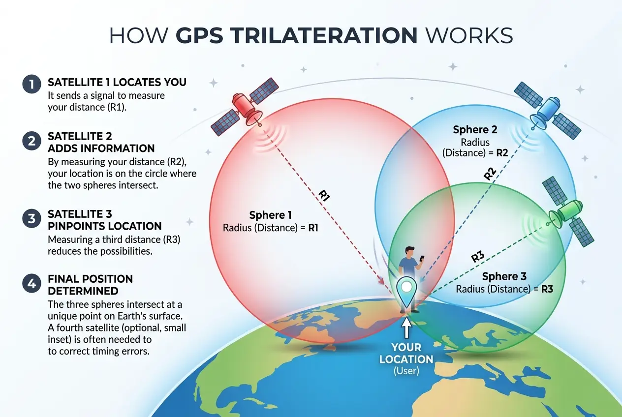
### Trilateration, Not Triangulation
Often, people mistakenly refer to the GPS positioning method as "triangulation." In reality, it's **trilateration**. While triangulation uses angles to find a position, trilateration uses distances. Imagine you know you are 10 miles from City A, 15 miles from City B, and 20 miles from City C. By drawing circles with these radii around each city, your position is the point where all three circles intersect.
In GPS, it's slightly more complex because we're dealing with spheres in 3D space, not circles on a 2D map.
* **One satellite:** Tells you you're somewhere on a sphere with that satellite at its center and the calculated distance as its radius.
* **Two satellites:** You're on the circle where two spheres intersect.
* **Three satellites:** You're at one of two points where three spheres intersect. One of these points is usually nonsensical (e.g., in outer space), so it's discarded.
* **Four (or more) satellites:** With a fourth satellite, the system can resolve not just your position but also eliminate the clock error of your receiver, giving you an accurate position and precise time synchronization. More satellites generally lead to greater accuracy, as the receiver can average out potential errors.
### The Einstein Factor: Relativity and GPS
Here's where it gets truly fascinating. The precision required for GPS is so extreme that even the fundamental laws of physics, as described by Albert Einstein's theories of relativity, must be taken into account. Without these corrections, GPS would be completely useless, with errors accumulating by several miles a day.
There are two main relativistic effects at play:
1. **Special Relativity:** Time runs slower for objects moving faster relative to an observer. GPS satellites are moving at speeds of about 14,000 km/h (8,700 mph) relative to an observer on Earth. This causes their atomic clocks to tick slightly slower by about 7 microseconds per day compared to a stationary clock on Earth.
2. **General Relativity:** Gravity warps spacetime, and time runs faster in weaker gravitational fields. Since GPS satellites are further away from Earth's massive gravitational pull than your receiver, their clocks experience a weaker gravitational field and, therefore, tick faster by about 45 microseconds per day.
When you combine these two effects, the net result is that the atomic clocks on GPS satellites appear to tick about 38 microseconds (45 - 7 = 38) faster per day than clocks on Earth. While 38 microseconds might sound negligible, remember that radio signals travel almost 300,000 kilometers in a single second. An error of 38 microseconds would lead to a positional error of approximately 10 kilometers (6 miles) per day!
To counteract this, engineers deliberately set the atomic clocks on GPS satellites to run slightly slower before launch. This pre-correction ensures that, once in orbit, the relativistic effects cause them to tick at the exact rate needed for accurate time synchronization with Earth-bound receivers. It's a testament to the profound accuracy of Einstein's theories that such subtle effects must be accounted for in a practical, everyday technology. You can learn more about this on Wikipedia's article on [GPS and relativity](https://en.wikipedia.org/wiki/GPS_and_relativity).
### Sources of Error and Enhancements
While GPS is incredibly accurate, it's not perfect. Several factors can introduce errors:
* **Atmospheric Delays:** The Earth's ionosphere and troposphere can slow down the GPS signals, causing slight delays. Scientists use models to correct for these, but perfect compensation is impossible.
* **Multipath Effect:** Signals can bounce off buildings, mountains, or other large objects before reaching the receiver, creating longer-than-actual travel paths. This is why GPS can sometimes struggle in urban canyons or dense forests.
* **Orbital Errors:** Although highly precise, the satellites' reported positions can have tiny inaccuracies.
* **Receiver Quality:** The quality of the GPS receiver itself, particularly its antenna and processing capabilities, plays a significant role in accuracy.
To improve accuracy, several enhancements have been developed:
* **Differential GPS (DGPS):** Uses fixed ground stations at known locations to broadcast correction signals, significantly reducing errors for local users.
* **Assisted GPS (A-GPS):** Used by smartphones, it leverages cellular network data (like cell tower locations) to quickly acquire satellite signals and improve initial positioning, especially indoors.
* **GNSS (Global Navigation Satellite System):** This is the umbrella term for all satellite navigation systems, including GPS (USA), GLONASS (Russia), Galileo (Europe), and BeiDou (China). Modern receivers can often use signals from multiple GNSS constellations, leading to even greater accuracy and reliability. This multi-constellation approach greatly enhances performance, especially in challenging environments. For a deeper dive into the world of global navigation, check out the [GNSS Wikipedia page](https://en.wikipedia.org/wiki/Global_navigation_satellite_system).
### The Future of Pinpoint Accuracy
The evolution of GPS and GNSS technology continues at a rapid pace. Newer satellites broadcast additional signals, offering greater redundancy and precision. Researchers are exploring ways to make GPS work better indoors and in areas where signals are weak, perhaps even using novel quantum technologies or leveraging Wi-Fi and Bluetooth signals as supplemental positioning tools. We might even see the integration of advanced AI algorithms to further refine location data, predicting environmental interferences and correcting for them in real-time. I've been following how AI is impacting various fields, and it's clear its influence on precision navigation will only grow, similar to how it's being used to decipher complex cosmic signals in areas like [can-ai-decipher-gravitational-waves-secret-language-8845](/blogs/can-ai-decipher-gravitational-waves-secret-language-8845).
The impact of GPS is hard to overstate. It has revolutionized everything from how we commute to how humanitarian aid is delivered. Farmers use it to optimize planting and harvesting, reducing waste. Scientists track wildlife migration patterns with unprecedented detail. Emergency services use it to find people in distress faster. Even the time synchronization provided by GPS is crucial for stable electrical grids and secure communication networks. It's truly a silent backbone of our modern world. And for those interested in other fascinating uses of time and location in ancient contexts, you might find our post on [did-ancient-astronomers-decode-cosmic-time-algorithms-3240](/blogs/did-ancient-astronomers-decode-cosmic-time-algorithms-3240) intriguing, though quite different from modern GPS. Another interesting read related to how ancient civilizations understood their position in the cosmos is our article on [did-ancient-sites-encode-cosmic-algorithms-3823](/blogs/did-ancient-sites-encode-cosmic-algorithms-3823).
### Conclusion
The next time your phone guides you flawlessly to a new restaurant or helps you find your way back from a hiking trail, take a moment to appreciate the incredible technology at play. It's not just a fancy map; it's a testament to human ingenuity, leveraging intricate physics and a network of precision instruments orbiting thousands of miles above us. GPS is a powerful reminder that some of the most profound scientific principles are often hidden in plain sight, quietly empowering our daily lives and connecting us to a global, invisible web of data and timing.
Frequently Asked Questions
A GPS receiver needs signals from at least four satellites to accurately determine its 3D position (latitude, longitude, and altitude) and to correct for any clock errors in the receiver itself. Three satellites can pinpoint a location, but the fourth is crucial for eliminating the receiver’s clock bias.
Atomic clocks are essential because GPS relies on extremely precise timing to calculate distances. Even a tiny error in time measurement would translate to huge errors in distance, as radio signals travel at the speed of light. Atomic clocks on satellites provide the ultra-accurate time stamps needed for the system to work effectively.
Yes, severe weather conditions can slightly affect GPS accuracy. Heavy rain, dense clouds, or atmospheric disturbances can cause minor delays or distortions in the satellite signals as they pass through Earth’s atmosphere, leading to small inaccuracies. However, these effects are usually minimal for most everyday uses.
GPS (Global Positioning System) is the specific satellite navigation system operated by the United States. GNSS (Global Navigation Satellite System) is a broader, overarching term that refers to all global satellite navigation systems, including GPS, Russia's GLONASS, Europe's Galileo, and China's BeiDou. Modern receivers are often GNSS-enabled, meaning they can use signals from multiple constellations for better accuracy and coverage.
GPS signals are generally weak or unavailable indoors, underground, or in dense urban areas (known as 'urban canyons') because the signals can be blocked or heavily attenuated by buildings and obstacles. While A-GPS on smartphones can use Wi-Fi and cell tower data to help estimate indoor positions, true satellite-based GPS struggles in these environments.
Verified Expert
Alex Rivers
A professional researcher since age twelve, I delve into mysteries and ignite curiosity by presenting an array of compelling possibilities. I will heighten your curiosity, but by the end, you will possess profound knowledge.
Leave a Reply
Comments (0)
No approved comments yet. Be the first to share your thoughts!
 Join Us


 Alex Rivers


Leave a Reply
Comments (0)